
[imagesource: Twitter / @ReenvalSA]
First, the skies unleashed great fury and caused flooding and destruction in KwaZulu-Natal earlier this year.
Then, Johannesburg was slightly waterlogged after the recent extreme hail storm that struck the region.
As if “extreme load shedding” in the coming weeks isn’t enough for Saffas to deal with, the rain (the hot rain, at that) has also been pouring in most parts of the Western Cape, causing major flooding in some areas.
The South African notes that yesterday, the South African Weather Service (SAWS) issued a level 5 warning for severe thunderstorms with hail for parts of the Western Cape, Gauteng, Free State, and North West.
The harsh lightning and thunderstorms began in the Mother City on Sunday night and continued into Monday.
As a result, Gordon’s Bay became completely waterlogged:
Cape Town – R44 Route: #Flooding at Gordons Bay pic.twitter.com/pmCKtRiY9v
— TrafficSA (@TrafficSA) December 12, 2022
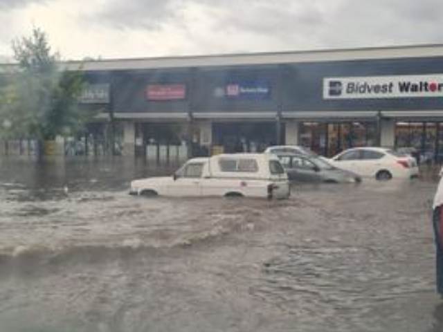
And Paarl also became awash with rainwater and flash floods:
Some low lying areas flooded in Paarl,WC this afternoon after thunderstorms hit the area.
Photos: Aj En Andrea Britzhttps://www.facebook.com/groups/reenvalsa/posts/5660189727429064/ pic.twitter.com/dEm02Hpj87— ReenvalSA (@ReenvalSA) December 12, 2022
There were far too many “floating cars and flooded gyms” in Paarl:
Floating cars and flooded gyms….. @CapeTown pic.twitter.com/L7bPfjWdn9
— Ant….Vanderas (@Ant_I_R_Legend) December 12, 2022
Road Safety and Flood Risks for Drivers and Pedestrians – Don’t Risk Driving through flowing Water!! https://t.co/D5OpMkTjUb #ArriveAlive @ReenvalSA @afriwx @tWeatherSA @WCGovSafelyHome [Video Received from Paarl] pic.twitter.com/TmmEXkFh7c
— Arrive Alive (@_ArriveAlive) December 12, 2022
The rain was even wreaking havoc inside buildings:
#ExtremeWeather Floods and Storms cause havoc in Paarl, Western Cape.. pic.twitter.com/w2KDDunffi
— SA911 (@JustdoitZee) December 12, 2022
IOL reported that Medicare EMR in Paarl confirmed that the hospital roof collapsed due to extreme floods and evacuation was in progress to bring all staff and patients to safety.
According to SAWS, widespread showers and strong winds over the Western Cape may keep coming this week, according to IOL:
“Heavy downpours (20-30mm/h), strong and gusty winds (40-50km/h, gusting to 60-70km/h), excessive lightning and large amounts of small hail (1-2cm in diameter) are possible.
“Redevelopment are expected over the extreme eastern parts on Tuesday, with possible large hail (2-3cm) and heavy downpours leading to flash flooding due to the high soil moisture content,” Saws said.
Potential effects included flash flooding of roads and susceptible settlements, danger to life in crossing fast-flowing streams, damage to vehicles and difficult driving conditions, possible major travel disruptions, loss of agricultural production, and disruption to essential services.
Disaster Risk Management spokesperson Charlotte Powell said that Cape Town does not often experience such long bouts of thunder activity, and the City endorses the safety tips issued by the weather service.
That includes, above all, staying indoors and away from dangerous areas and object in the event of extreme rainfall.
The Disaster Risk Management team and the Provincial Disaster Management Centre are reportedly on high alert.
[sources:iol&iol&southafrican]